Wednesday, November 15, 2017

I'm Dreaming of a White.... Thanksgiving???

Static Cold Pattern NE Next Week
Graphics Credit: AccuWeather
Millions of Americans are getting ready to hit the road for the Thanksgiving holiday, with the day of and the days around Thanksgiving being someone of the busiest travel days of the year. However, this year mother nature will make this a little more complicated for many of us throughout the country, whether we're traveling on the ground or in the air.

If you're making your holiday travels or just heading home for Penn State's Thanksgiving break over the weekend (Saturday 11/18 or Sunday 11/19), you'll probably encounter the potent storm system that will be passing through the Midwest and Eastern U.S. This cold front will dump some rain and produce some thunderstorms in the western Great Lakes, lower Ohio Valley, and mid-Mississippi Valley throughout the day on Friday 11/17. As the rain spreads to the Northeast on Saturday, some freezing rain, sleet, or snow is possible in upstate New York and in parts of northern New England. Additionally, flight delays are possible on Saturday in Washington D.C., Philadelphia, New York City, and Boston due to this weather system. This rain, and some thunderstorms, will stretch from the Great Lakes to Louisiana in the Central U.S., possibly causing flight delays at Chicago O'Hare, Detroit, Cleveland, Cincinnati, Pittsburgh, and Louisville. However, once this cold front pushes off to the east and out of the country, much colder temperatures will filter in behind it.

Static Lake Effect Snow Sat to Mon V2
Graphics Credit: AccuWeather
After the mild and wet weather to end this week, progressively colder air will unleash rounds of lake-effect snow from the Upper Midwest to the interior Northeast throughout the week of Thanksgiving and cause travel delays. Once the cold front passes through, cold and strong northwesterly winds will blow over the relatively warm waters of the Great Lakes. This will most likely cause lake effect snow bands to form on the southeast portions of all the Great Lakes from Saturday night (11/18) to Monday (11/20). Lake effect snow is especially challenging to travel in since the areas of heaviest snow are often times hard to predict and random, leading to drivers not being able to avoid the whiteout conditions that could happen. With lake effect snow, travel conditions can range from blinding snow and the potential for temporary road closures to sunny over a span of a few miles.

Throughout the week of Thanksgiving, two major pushes, or waves, of cold air are expected to move into the eastern half of the U.S. With the second push of cold air, strong northwesterly winds are again expected to be present over the Great Lakes from Tuesday night (11/21) to Wednesday night (11/22). This will most likely cause some more lake effect snow to form as the cold air passes over the relatively warm water. However, there is still uncertainty as to the extent or intensity of that round of lake-effect snow, since we're still around a week out from these dates. Anyone driving through the higher terrain in West Virginia, western Maryland and western and northern Pennsylvania should expect locally blinding snow squalls and a quick accumulation on roads.

Graphics Credit: The Weather Channel
As for temperatures, they are projected to be around 5-10 degrees Fahrenheit below normal for this time of year during multiple days next week (Thanksgiving week) from the Midwest to the Northeast. To add to that, winds will be strong at times making it feel cooler than it actually is.

As a note: the west and northwest United States should expect to see round after round of showers and thunderstorms throughout the Thanksgiving Day week, which will most likely hinder travel and delay flights around those areas.  

More details will arise later in the week in regards to forecasts of the weather over the course of Thanksgiving week, however motorists and airline passengers should anticipate delays and be ready to adjust their travel plans during the week of Thanksgiving, depending on where they live. Have a Happy Thanksgiving!

Wednesday, November 1, 2017

Welcome Mr. November: Major Changes Are In Store

November weather picture: snow accumulation can be seen on some trees along with colorful leaves - Photo Credit: Aram Boghosian for The Boston Globe
The feel of the crisp fall air as you walk out the door. The time of year when the shorts and t-shirts are retired for the year and the sweatshirts and jackets need to be broken out of the bottom of your drawers. Fall foliage is at its peak with trees displaying their true beauty, and snow, yes, snow begins to enter the conversation.

What a wonderful time of year it is as we flip the calendars over to November in 2017. But November also marks a time of the year when weather conditions are highly variable depending on the weather pattern that's in place as we transition from fall to winter. It's not out of the questions that we could see snow, severe thunderstorms, tornadoes, and hurricanes all throughout the month of November. With all of these weather events possible, it makes predicting all of them increasingly challenging.

Graphic Credit: The Weather Channel
The first event that the majority of Americans will experience at some point during the month of November is measurable snow. This may excite the snow lovers out there, including myself, while to others it may make them want to start wishing it was summer again. As exemplified by the graphic above, historically over the past thirty years, by the end of November a little more than about half of the United States has seen its first snowfall that can be measured (defined as 0.1 inches or more). This region includes central Pennsylvania and State College, so don't be surprised to see a few snowflakes falling from the sky as you walk around campus and possibly a measurable amount of snow at some point in the next thirty days.

November also typically brings powerful and more intense low-pressure systems sweeping across the contiguous United States, producing strong and even damaging winds. This is due to increased temperature contrasts from north to south across the country, with warm air still over much of the south and cooler air pushing in from the north. November has a long history of producing these intense storms over the Midwest, where they're commonly referred to as the "Witches of November," sometimes causing downed trees and widespread power outages. We've already seen a couple of these this season, with one of them bringing heavy rain and wind to the northeast region this past weekend.

Graphic Credit: The Weather Channel
Coupled with these strong low-pressure systems and cold fronts is the increased risk for tornadoes in what some refer to as the "second tornado season." Unstable conditions can form at times throughout November bringing large hail and possible tornadoes to the Gulf Coast states where warm, moist air can still be found. Going back in history to 1992, the largest fall tornado outbreak occurred from November 21-23 where a total of 105 tornadoes touched down, killing 26 people.
Image result for hurricane kate
Hurricane Kate, which made landfall in Florida just days before Thanksgiving in 1985 - Photo Credit: NOAA
Even though the hurricane season is finally winding down, and tropical systems are exceedingly rare to see develop around this time of year, it has happened in the past. November averages about one named storm every two years in the Atlantic Ocean, and I would not be surprised to see the record-setting 2017 hurricane season produce one last named storm.

And finally, bringing these weather events closer to home in Pennsylvania, the lake-effect snow season begins to ramp up throughout the month of November. Waters are still relatively warm in the Great Lakes and as cold air masses move their way over the region throughout the month, they will pick up this moisture and dump it as snow to the east of the lakes, including over some regions of Pennsylvania. These lake-effect snow events can dump a considerable amount of snow and last for several days, so be on the lookout, especially in northwestern Pennsylvania, for these lake effect snow events to pop up.
So what do meteorologists think this November will be like? According to the latest forecast from The Weather Channel, as seen above, it appears that we may experience a slightly above average temperatures throughout the month here in Pennsylvania. And as for precipitation, we're starting off the month on the rainy side, with plenty of rain in the forecast for the next seven to even ten days here in State College.

Have a great November and be sure to keep up-to-date on the weather forecasts throughout this month of variable and unsettled weather!

Wednesday, October 25, 2017

Here Comes the Cold.....What's in Store for this Winter?

Static Eastern US Temperature Trends
Credit: AccuWeather - Two cold fronts will bring us chilly weather this week and into the future
It's that time of year again. The 70 degree days are becoming a distant memory and it's time to brush that dust off of your winter jacket. The thrills of the summer are leaving us behind and the bitter, winter weather is heading our way.

As a big skier myself, I love the winter, the cold weather, and plenty of snow, but these views are often the opposite of the majority of the general public. When most people see below freezing temperatures they just want to stay under their nice warm covers all day, not daring to step a toe out into the "bitter cold tundra."

This week marks the beginning of the shift in the weather in Pennsylvania from abnormally above-average temperatures that we've experienced throughout the majority of September and October to much cooler and more seasonable temperatures that we should be experiencing around this time of the year. The lovers of the warmer weather have been spoiled and lured over a trap door by the temperatures ever since the beginning of the semester in mid-August. But now Mother Nature has finally caught up and she's making up for lost time by dropping our temperatures into the mid-50's for highs and upper 30's for overnight lows, taking many people by surprise if they weren't following the weather forecasts.

Credit: High Plains Regional Climate Center - The Northeast has been six to nine degrees above the normal temperatures for this time of the year throughout the month of October
Dominant ridges of high pressure, associated with sinking air and clear skies, had dominated our region for the majority of October leaving us with beautiful sunny skies and a time period where we didn't see rain for weeks. But we were greeted with a "fall reality check" this week when a sharp cold front passed through Pennsylvania Monday night and throughout the day on Tuesday. On Wednesday morning we were greeted with temperatures in the upper 30's for the first time in awhile and highs not even reaching the 50 degrees mark in the central PA area.

In September and October, we had one or two blasts of cooler air but they didn't stick around for too long. I'm confident that this cooler, more seasonable weather that we're just beginning to experience will stick around for the foreseeable future, especially because of a reinforcing shot of cold air this weekend. We should expect another significant rainfall on Saturday night and into Sunday, possibly dumping more than 2 inches of rain in our area, as a cold front passes through. This will help to keep our temperatures around the low 50's for highs and upper 30's for lows. With these colder temperatures, the chance for frosts increases as we could possibly see lows below 32 degrees soon enough.

Static Snowfall Thurs Friday Upper Midwest
Credit: AccuWeather - Snow will fall for the first time in Minnesota and Wisconsin later this week
These blasts of colder air are also creating some snow in portions of Minnesota and Wisconsin heading into this weekend. We won't see snowflakes in our area in the next week or so, but if these colder temperatures continue to stick around, our first snow will come sooner rather than later.

Along with the cooler temperatures becoming more prevalent around this time of year, this is typically when we start to see forecasts for the upcoming winter coming out. Forecasting a whole season ahead is not an easy task and often times the forecasts aren't too reliable, but they can give us a good baseline and something that we can look ahead to. Winter forecasts are comprised of two maps, the first of which is a temperature map showing specific areas of the United States that are forecasted to be above or below average temperatures for the winter months. The other map is a precipitation outlook displaying if it will be wetter or drier than average for specific portions of the U.S. based on the forecasts.

Credit: NOAA

Credit: NOAA
Based on these maps, it appears that central Pennsylvania has a slight chance of having a warmer and wetter than average winter. Many other sources, such as AccuWeather and The Weather Channel, release maps similar to these every year with each source having a map that is slightly different than the others. The reason for many of the maps showing this general type of a pattern is due to the La Niña that's forming in the eastern Pacific Ocean.

Current Sea Surface Temperatures - blue colors are colder waters, red and orange colors are warmer waters. You can see the clear line of colder temperatures off the coast of northern South America which denotes a La Niña.
There's a good chance that a La Niña will form this winter, where sea surface temperatures are colder than average off to the west of South America, and by using data from past La Niña's meteorologists have come up with the current forecasts for this winter. However, I wouldn't take these forecasts to heart as something that will definitely happen; we'll just have to wait and see what Mother Nature brings us.

Are you hoping for the slightly wetter and warmer winter that's currently being predicted for Pennsylvania or would you rather have a drier and cooler winter?

Wednesday, October 18, 2017

Should Climate Change Be Under Arrest? The 2017 Hurricane Season So Far

Cartoon credit: Wisconsin State Journal
Relentless. Destructive. Devastating. Catastrophic.

These are just some of the many adjectives used to describe the endless barrage of hurricanes that have directly impacted the United States in the past few months. 

Hurricane Harvey - Photo Credit: GOES-16/NASA
Hurricane Harvey (August 25 - September 3) struck the coast of Texas on August 25, bringing damaging category four strength winds and record-setting rainfall totals to the Houston-metropolitan area. Harvey was officially the first major hurricane (category three strength or higher) to make landfall in the United States since Hurricane Wilma did so 12 years ago in 2005. It seemed just as Harvey moved its way out of the southeast Texas area, leaving billions of dollars in damage in its wake, everyone's focus shifted to the next tropical system brewing off of the coast of Africa. 

Hurricane Irma - Photo Credit: USA Today
Hurricane Irma (August 30 - September 16) surely made a name for itself in its own right, smashing numerous records and wreaking havoc wherever its path took it. Perhaps the most striking statistics about Irma was how strong it was and for how long it was this powerful. It tied the record for the longest time as a category five hurricane and it now holds the record for sustaining it's maximum wind speeds of 185 mph for an incredible 37 hours. The first land mass in the path of Irma was a tiny island in the far northeastern part of the Leeward Islands named Barbuda. This is when we saw the true power of this system, as Irma demolished over 90 percent of the buildings and vehicles on the island, before impacting other islands in the Caribbean on its way towards the U.S. mainland. Irma made landfall as a category four hurricane on the Florida Keys on September 10 and impacted the entire state of Florida with flooding and damaging winds. 

Hurricane Maria - Photo Credit: FiveThirtyEight
Once Hurricane Irma dissipated, Hurricane Maria (September 16 - October 3) quickly took its place in the Atlantic basin. Maria quickly developed into a major hurricane in a matter of days just to the east of the Lesser Antilles. A mere two days after it had formed, Maria struck the small island of Dominica as a category 5 hurricanes with winds up to 175 mph and then marched its way up to the island of Puerto Rico, home to over 3.4 million people and a U.S. territory, where it made landfall has a high-end category four storm. Maria caused catastrophic damage and a major humanitarian crisis in Puerto Rico, and many of President Trump's controversial actions in response to Hurricane Maria are very prevalent in the news today. Maria proceeded to take a turn out to sea, luckily not making landfall on the continental United States. 

Hurricane Nate - Photo Credit: New York Magazine 
However, Mother Nature produced one more storm out of the Gulf of Mexico, Hurricane Nate (October 4 - 11), which impacted parts of Mississippi and Lousiana as a category one hurricane. Even though the impacts of Hurricane Nate were not nearly as widespread as the effects of Harvey, Irma, or Maria, Hurricane Nate was the fourth hurricane to make landfall on the United States or a U.S. territory in the 2017 hurricane season. 

All four of these hurricanes made landfall on the continental U.S. or a U.S. territory, while all occurring essentially back-to-back. Looking at the dates when each of these tropical systems formed and dissipated, from August 25 all the way to October 11 there's been a tropical system to talk about in the Atlantic basin that would eventually directly impact the United States. 

But what does climate change have to do with all of this? What role did climate change have in making the 2017 hurricane season overly hyperactive and one of the worst on record?

Many scientists realize that it's very hard or even impossible to draw a distinct line between climate change and an individual storm or hurricane. But when looking at the bigger picture, many scientists agree that climate change doesn't create more tropical systems, but that climate change may make the tropical systems that do develop more intense.
Change in sea surface temperature from 1901 to 2015 - Photo Credit: Environmental Protection Agency
This is because climate change causes ocean temperatures and sea levels to gradually rise. Since hurricanes feed off of the energy from warm sea surface temperatures, warmer waters mean that hurricanes have more energy to take in and use to intensify. Additionally, since hurricanes usually generate a great deal of storm surge, where ocean water is pushed on-shore due to the winds of the hurricane, higher sea levels can exacerbate this issue, causing higher levels of storm surge and worse flooding. 

2017 Tropical Storm and Hurricane Tracks - Photo Credit: Wikipedia
When looking at the 2017 hurricane season in more detail, so far we've had 15 tropical storms and 67%, or 10, of those further intensified into hurricanes. Furthermore, 60% of those 10 hurricanes strengthened into major hurricanes (category three or higher), demonstrating the point that storms will not necessarily be more prevalent, but rather more intense. 

Another measurement that meteorologists like to take on hurricanes is the Accumulated Cyclone Energy (ACE), which approximates the wind energy used by a tropical system over its lifetime. The ACE for the 2017 hurricane season was 221, which is the highest since the 2005 hurricane season had an ACE of 250. However, since the 2005 hurricane season had 28 total tropical systems, the ACE per tropical system in 2005 was only about nine compared to about 15 per tropical system during this years hurricane season. This evidence supports the argument that hurricanes are now more intense and stronger than ever, possibly due to the effects of global warming. 

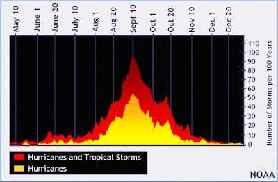
Graph showing when the peak of the hurricane season usually is - Credit: National Hurricane Center
Even though we've made it past the peak of the hurricane season, which is around September 10, we're not out of the woods in terms of seeing another hurricane develop in the Atlantic before it shuts down for the winter. For instance, we just saw Hurricane Ophelia, now the easternmost Atlantic major hurricane on record, impact Ireland and the United Kingdom with some high winds and rain, so who knows what will come next. 

What we do know is that it may be time to put climate change "behind bars" for contributing to one of the worst hurricane seasons ever. 

Wednesday, October 11, 2017

The Fire That Burns On Out West

Photo Credit: NPR

It seems as if California is perpetually on fire.

I'm sure many of you have heard of the drought that California seems to have been in for the past ten years. These low-rain situations cause forests to be breeding grounds for wildfires to start and spread quickly. Contrary to popular belief, it's actually normal for some wildfires to occur throughout the year. Naturally occurring wildfires play an integral role in nature by returning nutrients to the soil through the burning of dead or decaying matter.

Photo Credit: ABC News
But the wildfires that are currently happening in Northern California are getting out of control this year and appearing in more places than usual, causing death tolls from these wildfires to rise. According to the Weather Channel's latest update, the wildfires are rapidly approaching and engulfing Northern Califonia towns so evacuation orders are continuing to be issued. Additionally, at least 21 deaths have been confirmed and more than 3,500 homes and businesses have been burned to the ground. Firefighters continue to be deployed by the hundreds to constantly try to fight these unrelenting flames, but they're fighting a losing battle.

Strong winds, upwards of 30 mph, coupled with the bone-dry conditions and low humidity levels, have helped the wildfires expand at rates that the firefighters cannot compete with. This is leading many people to call these wildfires among the worst that they've seen in Califonia history.

Photo Credit: NPR
The wildfires have also displaced over 4,400 people from their homes to shelters hoping to avoid the deadly blaze and smoke-filled air. The flames have already consumed over 265 square miles, expanding from 17 fires currently burning on Tuesday to 22 fires on Wednesday. Chief of the California Department of Forestry and Fire Protection says, "Make no mistake, this is a serious, critical, catastrophic event." Over 8,000 firefighters and other personnel are currently battling the flames that are already the most destructive in state history, and the worst has yet to come.

The harrowing descriptions of the current conditions in Northern California and some of the stories of people being encompassed by the fire are truly bone-chilling. One resident described it as "an inferno like you've never seen before" with the "trees on fire like torches." One couple, of ages 100 and 98, died in their house on Tuesday after they were unable to evacuate before the flames took over their home. Another resident died while trying to escape the wildfire in her car. People who are just in the vicinity of the fires are also experiencing negative effects from smoke inhalation. Air quality in Napa County, the county just northeast of San Fransico, is "very unhealthy" and "hazardous." Additionally, low visibility from the smoke is causing average delays of three hours at the San Fransico International Airport.

Along with historic sites being destroyed, important wineries are being burned down by the wildfires. The flames have already consumed at least five wineries with many others being threatened as the fires continue to expand.

Photo Credit: ABC News
I think the "We Didn't Start the Fire" lyrics by Billy Joel are very appropriate for this catastrophic
event:
"We didn't start the fire
It was always burning since the world's been turning
We didn't start the fire
No, we didn't light it, but we tried to fight it."
Hopefully, firefighters can continue to try to fight the flames, so that parts of Northern California are not completely destroyed much like the city of Santa Rosa was earlier this week. As you can see in the video below, entire neighborhoods in Santa Rosa were burned to the ground, the fires destroying anything in their path, including historic sites, stores, hotels, and homes.


Forecasts for Santa Rosa do not call for any rain in the next seven days, and wind speeds look to continue to be steady, easily spreading the fire throughout the region. Hopefully, the flames will eventually be contained and recovery efforts can begin in Northern California.